Bribie Island, Queensland – multiple views (Australia)
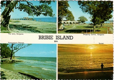
Bribie Island is the smallest of three major sand islands forming the coastline sheltering the northern part of Moreton Bay. It’s 34km long, and 8km at its widest. One view held that the name came from a corruption of a mainland word for it, Boorabee, meaning koala; however, the correct Joondaburri name for the island is Yarun. Bribie Island tapers to a long spit at its most northern point near Caloundra, and is separated from the mainland by Pumicestone Passage. Most of the island is uninhabited national park (55.8 sq. km) and forestry plantations but the southern end of the island has been intensively urbanised as part of the City of Moreton Bay. A bridge from Sandstone Point on the mainland to Bellara and Bongaree was completed in 1963. And this card? Mailed in 1976, the card’s views are all identified, more or less. Stamp, air mail sticker, and the postmark are there. Card has serrated edges. Grade: 1